Dunkirk and the Atlantic Wall
- pd-allen
- Jul 4, 2025
- 12 min read

During my visit to the Channel Ports, I stopped at a number of Atlantic Wall fortifications and visited Dunkirk, the site of the great retreat of the British Expeditionary Force (BEF) in May 1940. The area between Boulogne and Dunkirk is the most heavily fortified portion of the Atlantic wall, due to its proximity to England. Hitler was convinced the assault would happen in this region, so much so that he initially assumed the D-Day Invasion in Normandy was a diversion and that the actual invasion would take place in the region of he Channel Ports.
With my usual over optimistic time appreciation, I mapped 75 locations from Dunkirk to Boulogne to visit over a 3 day period (Different colour for each day) using the excellent Normandy Bunker website. Fortunately, I came to my senses and picked a few must see locations to visit.
Dunkirk
Background
The Germans invaded Poland on 01 September 1939, and France and Britian declared war on Germany 2 days later. Following the Polish invasion, there were no major battles for an extended time, leading to that period being called the Phoney War.
The Phoney War ended on 10 May 1940 when the Germans invaded Luxembourg, Belgium, the Netherlands and France with their Blitzkrieg (Lightning War) attack. Army Group B smashed through the Netherlands and forced their surrender on 14 May. The German Army Group A captured the Belgium Fort Eben Email, described in a previous post, with a daring glider Assault and the path through southern Belgium and northern France lay Open. The Germans avoided the heavily defend French Maginot Line and drove their Panzer divisions through the Ardennes Forest, which the French had assumed was impassible for tanks.

Army Group B swept through France in record time, reaching the coast on 20 May and effectively cutting the Allied forces in half.

The British and 1st French Army were surrounded so the British General Gort realized that evacuation was their only chance to save their troops. Boulogne fell on 25 May and Calais a few days later so Dunkirk was the only viable evacuation port. The British and French Army fought desperate rear-guard actions to slow the advance of the Germans. They dug in on the sides of canals and rivers and held back the Germans as long as possible to allow more troops to evacuate.

Halt Order
After smashing through the low countries and France, on 24 May, the order was given to Halt the Panzer assault towards Dunkirk. Army Group A commander, General von Rundstedt, issued the Halt Order, later confirmed by Hitler. They were concerned that the tank divisions were over-extended and were worried about counterattacks. The area around Dunkirk was low-lying and had a myriad of canals, so was not considered good tank country, and General Goring, the Luftwaffe commander boasted the German Air Force could finish off the Allies. They also severely underestimated the ability of the Allies to evacuate large numbers of troops. This 48-hour pause gave the Allies time to bolster their defences and organize the evacuation. Many German field commanders were furious at the halt, and it is generally considered to be the greatest German blunder of the war.

Operation Dynamo
Operation Dynamo, the evacuation of the Allied troops, began 26 May. Dunkirk had been heavily bombed for days so the port facilities were in ruins. The initial plan was to load the troops directly off the beaches. The troops were gathered along the beaches and dunes from Dunkirk to Le Panne. The British government expected to be able to rescue only 30,000-45,000 soldiers in this Operation.

Beaches
The beaches are very long, the problem is the area is very shallow, and the tide ran about 5 metres, exposing several hundred metres of sand at low tide. Only the smallest ships could approach the beach so only small numbers could be taken off in each load and they would have to be transferred to larger ships waiting offshore.
The Royal Navy generated a list of all boats that would be suitable for approaching close to the shore and commandeered a large number of them and staffed them with Navy personnel. They took the boats across the Channel on barges and used them to ferry the stranded troops from the beaches to larger ships moored offshore.

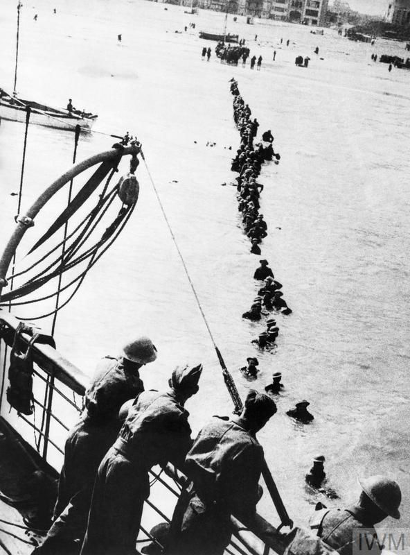
The popular image of the civilian population bravely facing enemy fire to sail the channel and pick up soldiers is largely a myth. 750 to 800 little ships were used during the evacuation, including pleasure craft, fishing vessels, lifeboats, barges and ferries. Very few owners took their own vessels, apart from fishermen and a few others, the majority were crewed by Navy personnel. This picture is from the Dunkirk (2017) movie. Some historians berate the historical accuracy of the movie, but it does a good job showing the scale of the action.

The Area from Dunkirk to De Panne is largely beach front. Three main pickup areas were on the Beach east of the port of Dunkirk, Bray Dunes and De Panne.

The troops were huddled on the dunes or strung out in lines along the beaches and were very vulnerable to attack.

The troops on the beach were subject to regular bombing and strafing attacks from the Luftwaffe and, as the Dunkirk Pocket continued to shrink during the latter stages of the evacuation, German artillery as well.

At the height of the evacuation, masses of troops await to board the rescue ships.

As the small ships come close to the shore, the troops waded out to meet the boats.

Happy troops aboard a rescue ship.

On the beaches, the engineers built makeshift wharfs using the abandoned vehicles and anything else they could scrounge to allow the small ship to load the evacuees directly.

The Beach east of the port.

The beach at Bray Dunes. The fortifications were not built until later in the war.

The Beach at De Panne. The peaceful seaside settings don’t give any indication of the chaos on the beaches in 1940. The tide is not all the way out in this picture.

In De Panne, there is a memorial to the French 12th Motorized Infantry Division.
Approximately 18,000 French soldiers were killed and 40,000 captured during the defence and evacuation of Dunkirk. About 123,000 soldiers were successfully evacuated to England although many returned to France and were captured when France fell on 25 June.

The Translated inscription:
THE 12TH MOTORIZED INFANTRY DIVISION
JANSSEN DIVISION
AFTER 15 DAYS OF HARD FIGHTING IN BELGIUM AND FLANDERS
VALORANTLY DEFENDED THE EASTERN SECTOR OF THE DUNKIRK BRIDGEHEAD AND CONTRIBUTED BY ITS SACRIFICE TO COVERING THE EMBARKATION OF THE ALLIED TROOPS. OVERWHELMED BY NUMBERS, IT SUCCUMBED ON JUNE 4, 1940, HAVING COMPLETELY COMPLETED ITS MISSION
YOU WHO PASS BY, REMEMBER THE HEROISM OF THESE SOLDIERS
106 EMER.1 25 ME RA
8TH ZOUAVES
150 RME RI 225MB RA
3RD G.R.DI
DIVISIONAL ELEMENTS AND SERVICES
The Mole
The Allies discovered they could pull their larger ships up to the Eastern Breakwater, called the Eastern Mole, and load the evacuees directly aboard the ships, providing much faster loading. They built an improvised walkway so the soldiers could pass 4 abreast. The term mole comes from an older nautical and engineering usage, meaning:
“A large solid structure on a shore serving as a pier, breakwater, or causeway.”

The Dunkirk Harbour fuel depots had been bombed, and the smoke covered the activities of the mole for several days before the Germans discovered what was going on. The English Channel was unusually calm for the evacuation period allowing small boats to cross safely and the troops not have to wade through a high surf. Low cloud cover shielded the troops from aerial attack and the RAF put up a stout defence to minimize exposure to the fighters and bombers.

The use of the mole allowed larger ships to dock and quickly load on passengers. The troops lined up to await salvation. The mole was bombed many times and gaps in the walkway were bridged by planks. Although there were casualties, the Mole was used throughout the evacuation.

Aerial view of the Dunkirk Harbour today. The Mole is the long walkway in the centre of the photo. Today the walkway does not extend across the entire mole.

Entrance to the Mole today.

Side view of the Mole with the lighthouse on the Western Mole.

Summary of the Rescue
More than 930 ships were involved in the rescue, including more than 700 small ships. A total of 305 ships were lost to Luftwaffe bombing, Artillery, Naval Mines, Torpedo attack and collisions in the chaos. Over 338,000 troops were rescued, 218,000 British, 120,000 French and Belgians. The daily breakdown shows that about 2/3 of the troops were rescued from the Mole.
Date | Beaches | Harbour | Total |
27-May | — | 7,669 | 7,669 |
28-May | 5,930 | 11,874 | 17,804 |
29-May | 13,752 | 33,558 | 47,310 |
30-May | 29,512 | 24,311 | 53,823 |
31-May | 22,942 | 45,072 | 68,014 |
01-Jun | 17,348 | 47,081 | 64,429 |
02-Jun | 6,695 | 19,561 | 26,256 |
03-Jun | 1,870 | 24,876 | 26,746 |
04-Jun | 622 | 25,553 | 26,175 |
Totals | 98,671 | 239,555 | 338,226 |
The British were originally only concerned with rescuing their own troops, but international pressures forced them to rescue the French as well. Approximately 40,000 French troops who had bravely fought the rearguard action to protect the troops on the beaches were captured when the evacuation ended on 04 June. They were forced to surrender after exhausting their supplies and ammunition. In a rare show of respect, the Germans allowed the French troops to march out with weapons and full military honours. Most of the captured troops remained prisoners for the duration of the war.
During the entire campaign, from 10 May until the armistice with France on 22 June, the BEF suffered 68,000 casualties. This included 3,500 killed and 13,053 wounded. Most heavy equipment had to be abandoned during the various evacuations, resulting in the loss of 2,472 pieces of artillery, 20,000 motorcycles, nearly 65,000 other vehicles, 416,000 long tons of stores, more than 75,000 long tons of ammunition, and 162,000 long tons of fuel. Almost all of the 445 British tanks dispatched to France were abandoned.
Memorials at Dunkirk
There are a number of memorials at Dunkirk. On the boardwalk leading to the Mole there is a monument.

The translated text reads:
TO THE GLORIOUS MEMORY OF THE AVIATORS, MARINES AND SOLDIERS
OF THE FRENCH AND ALLIED ARMIES
WHO SACRIFICED THEMSELVES IN THE BATTLE
OF DUNKIRK MAY JUNE 1940
Monument to the Navy Personnel involved in Dunkirk.

The artist chose the Hourglass, a symbol of passing time, as an analogy for the Allied soldiers trapped in the Dunkirk pocket who slowly trickled out to sea as the were evacuated. This work, which commemorates the success of Operation Dynamo, also pays homage to the soldiers who were killed or reported missing between 26 May and 04 June 1940. Moreover, the Hourglass symbolizes the possibility of a reversal capable of turning a defeat into a victory.

Atlantic Wall Fortifications
I stopped at a few Atlantic Wall sites to look at the German defensive systems.
Boulogne
In my previous post, I talked about the fortifications around Boulogne. Worth a read if you haven’t seen it.

The number of fortifications around Boulogne was very impressive. You can see why the Germans thought that the Channel Ports were a likely invasion site due to its proximity to the UK.

Batterie Todt (Cap Gris Nez)
The fortification locations between Boulogne and Calais.

The gun emplacements at Cap Gris Nez, particularly the Batterie Todt, were among the most formidable coastal artillery positions built by Nazi Germany during World War II. Located at the narrowest point of the English Channel, just 34 km (21 miles) from the British coast, these emplacements were designed to dominate the Channel and support a potential invasion of Britain.
Batterie Todt featured 4 380 mm (15 inch) naval guns with a range of 55 km, capable of hitting targets on the English coast. The shells were over 2 m high and weighed 800 kg. The Batterie fired 40 to 50 rounds a day and routinely targeted Allied Convoys and Dover and surrounding areas.

The layout of the Bunkers at Batterie Todt.
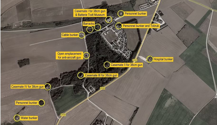
Casemate I now houses the Batterie Todt Museum. Within the existing bunker there are very good displays of the gun and the supporting weaponry, as well as the layout of the support facilities and barracks.

An original picture of the bunker and gun.

The present-day configuration of the gun port.

Profile schematic of the gun platform. The gun could elevate to 52 degrees for maximum fire ranges.

Size of the barrel.

Scale of the gun breech.

There were a number of ports in the rear wall of the bunker for storing and loading rounds. A small rail system was used to deliver the shells.

Each casemate was independent, having their own generator, communications room, and barracks. The museum had a number of plan views to help orient your tour.


The guns were part of the German coastal artillery under the command of the Kriegsmarine (Navy). One officer and 18 sailors supported each gun.
One of the other casemates was heavily damaged by an explosion after the war.

Casemate 4 off in a field.

The museum also has an in-depth section on the Canadian capture of the Batterie. The 9th Brigade moved up after taking Boulogne on 22 September. 857 aircraft bombed the batteries in the region on 26 and 28 September, and the attack went in on 29 September. At 0630, a Canadian officer with a white flag knocked on the door of one of the blockhouses and ordered the Germans to surrender. They declined, so the attack went in and by 1030 the commander of Batterie Todt surrendered. The Canadians suffered 5 dead and 37 wounded while taking as Prisoners of War, 26 officers and 1,500 soldiers.

The museum also acknowledges the commanders of the 9th Brigade.

The remains of a Canadian shell are still embedded in one of the bunker walls.

Outside the museum is a memorial to the capture of the site.

The plaque reads:
In memoriam of the Canadian soldiers of the
North Nova Scotia Highlanders Regiment
Who liberated the area on September 29, 1944
Adjacent to the museum is one of the two remaining examples of the Railway gun. The Railway gun could fire shells more than 60 km and had a built-in crane to handle the rounds.


Cap Blanc Nez
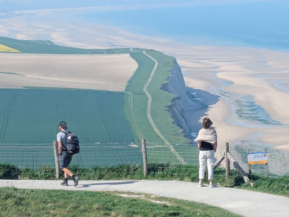
About 15 km up the road from Cap Gris Nez is Cap Blanc Nez, a strong point and Radar Station. Cap Blanc Nez is on a ridge 427 feet high overlooking the English Channel.

The Cap is on a cliff’s edge and the rapid rise in the terrain make it the perfect spot for a Radar Site and gun emplacements as it dominates the landscape. The height of land provides spectacular views of the area and on a clear day you are supposed to be able to see the White Cliffs of Dover. It was pretty clear when I was there, but I could not spy the cliffs.
There are extensive hiking trails throughout the region making this a very popular tourist destination.

The collection of bunkers that guarded the radar sites.

Dominating views to the East and West. Again, the huge tidal flats are clearly visible.

There are several of the observation posts on site.

At the peak of Cap Blanc Nez is one of the Dover Patrol Monuments. The second monument is in Dover, UK and the third in Brooklyn, NY. The monuments are dedicated to the Dover Patrol ships that escorted convoys, did mine sweeping and laying British mine fields. The first stone was laid by Marshal Foch in January 1920 and the monument was inaugurated by French Navy Minister Flamininus Raberti on 20 July 1922. When the Germans captured the region in 1940 the monument was destroyed and finally rebuilt in1967.

The inscription translates to:
“To the French and British sailors of the Dover Patrol, 1914‑1919, who died for the defence of the Strait.”
Battery Oldenburg
Situated just east of Calais is Battery Oldenburg, one of the largest Gun batteries on the French Coast, built to defend the port of Calais. The two large gun emplacements feature captured 9.5-inch Russian Guns.

Back of one of the gun casemates.

Second gun casemate and observation post.

View of the second casemate from atop the first one.

View of the port of Calais. The tops of the casemates were sodded to help hide the bunkers.
A number of bunkers are accessible in the scrubland near the port.

Drone view of the Observation post atop the hospital.

Batterie Zuydcoote
Zuydcoote’s fort battery was originally built in 1878 a few km east of Dunkirk to protect the port. It was upgraded and integrated into the 1940 Maginot line. As is the case with many of the old forts in the region, the Germans built on top of existing fortications as part of the Atlantic Wall.
Dunkirk was not taken like Boulogne and Calais. It was heavily bombed in the summer, and surrounded by Canadians and the Poles in September. Instead of a costly frontal assault, the decision was taken to seal off Dunkirk and seige the city. The civilians were evacuated and the city isolated.
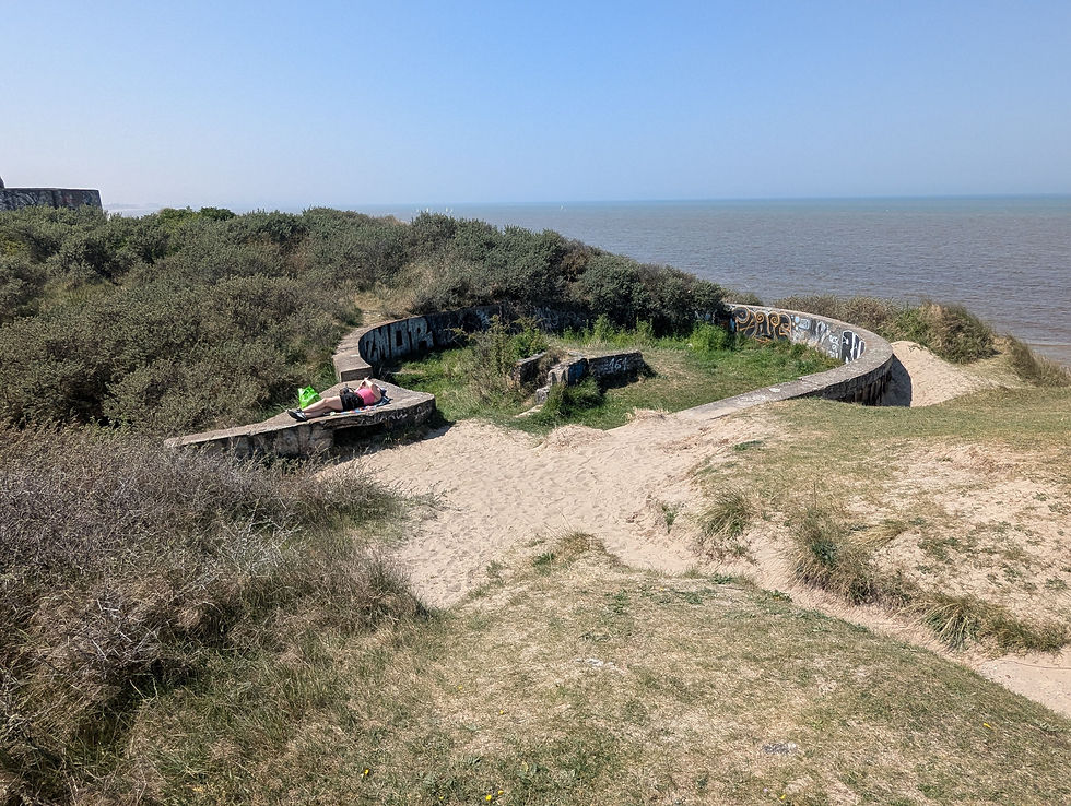
The German bunkers were built on the tall sand dunes so a number of fortifications have fallen to the beach.

The back of the German Observation Post showing the original French Fort.

Many of the bunkers have fallen onto the beach. This allows you to get different perspectives on the structure and provides easy access to graffiti artists.

More graffiti. The painting takes back its rights.

The erosion of the dunes causes bunker littering the beach.

Bunkers scattered like toys.

Gun emplacement showing its base, graffiti not so impressive.

One of the gun emplacements that landed right side up.

Observation post still on the look out.

Another gun emplacement on the beach.

The amount of detritus on the beach gives an indication of the number of structures in the Battery.

Side view of one of the Observation Posts.

Storage bunkers behind the front lines.

Bunkers back in the dunes.

A local chilling in an old gun emplacement in the dunes.
The graffiti on these structures is generally very creative. I particularly liked the lobster.

Final Thoughts
The story of Dunkirk was a tactical disaster that turned into the Miracle of Dunkirk. This gave rise to the Dunkirk Spirit, keep calm and carry on, that saw Britian through the dark days of the war. If the BEF had been wiped out, it would have prolonged the war as the 200,000 soldiers who escaped became the key cadre of soldiers for the British Army. It would not have been the end but was certainly a key turning point in the war. I watched Dunkirk on the latest flight to Amsterdam; I am keen to watch it again after having done a bit more research.

As you may have guessed, I am fascinated by the Atlantic wall structures and layouts. I visited a few spots, but there is a lot left to explore. I really don’t care for the European buildings that are randomly tagged, but I really liked the well-done graffiti on the bunkers at Zuydcoote. You have the symbolism of the bunkers that represent the enormous effort the Germans put into the Wall decorated by graffiti that helps put the war into perspective.


Mr McMillan, in Grade 10 History) didn't hammer Dunkirk into my head very well. I knew the name but was always confused about when it took place and how important it was. Reading about the Maginot Line, he did pound in a brief remembrance of that. Much clearer in your post. I can see that you enjoyed seeing a graffiti Lobster, telling you to get to New Brunswick. Great post and sorry for the delay in commenting.