Slovenia in WWI
- pd-allen
- May 20, 2025
- 10 min read
Updated: Jun 29, 2025

Prelude to War
Once we decided to visit Slovenia this Easter, it was mandatory that I look into the battlefield situation. I knew Slovenia was part of Austria-Hungary in WWI but beyond that I didn’t really have any idea of what had happened there.
Austria-Hungary was allied with Germany in the Central Powers against the Triple Entente of UK, France and Russia at the start of the war. Italy had been allied with the Central Powers, but when the war started, they declared it was only a defensive alliance and decided to remain neutral while they figured out which side would win. In the early days of the war, the Central Powers had a decided advantage, so Italy negotiated with them, but the Italian demands for weapons and artillery were excessive so the Kaiser declined to support them. In a secret agreement with France and the UK in April 1915, Italy agreed to join on the Allied side in exchange for land the Italians considered part of their heritage. On 23 May 1915, Italy declared war on Austria-Hungary much to the surprise and dismay of the Central Powers.
Since Italy was a former ally, the border in present day Slovenia was very lightly guarded. The Italians were commanded by General Cadorna, an egotistical commander who believed in frontal assaults to generate Napoleonic type breakthroughs, despite the failures on the western front. Cadorna believed he would breakout, push through the Ljubljana plain to Vienna by Christmas (sound familiar?) so took his time to mobilize and set up his attack. The front was 600 km long, almost as long as the Western Front, stretching from Switzerland to the Adriatic Sea, a 3D version running through the Alps.

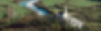
The main battlefields were in Trentino in the North-West and along the Isonzo (or Soca) River on the current Slovenian Border. All of the locations have an Italian and a Slovene name, as the region changed hands several times over the centuries. Since we were in the area, we did a drive up the Isonzo (Soca) River, the site of 12 bloody battles of the Isonzo River.
Isonzo (Soca) River Valley
We’ll call it the Soca River because we were touring Slovenia. The river is 140 km long, starting in the Julian Alps and flowing into the Adriatic. The river is a lovely emerald green, with steep gorges and narrow valleys surrounded by high mountains.

The valley is very narrow in places, and the road crosses the river several times as there is very limited flat land. The Soca River colour is due to the fact that it flows through limestone and dolomite and the fine grains of Calcium Carbonate reflect the green colour. The mountain rivers have very little pollution so are extremely clear, letting the sunlight penetrate and reduce the amount of algae growth.

The Soca is one of the most visually stunning rivers in Europe. These days, the river is a haven for outdoor enthusiasts but in places very fast flowing and being mountain fed, very chilly.

The Soca River was first crossed near Kobarid (Caporetto) by a wooden bridge in ancient times. That bridge was destroyed by the Venetians in 1616. The Napoleon Bridge was built with stone in 1750. The bridge was so called as Napoleon’s troops marched across the bridge while conquering large portions of present-day Slovenia. The Austrians blew the bridge in WWI. The Italians subsequently built a wooden, then an iron bridge to support their war efforts. The bridge was rebuilt after the war to its current configuration.

Kayakers enjoying the Soca River and Rachel enjoying the view.

Both the River and Valley are very narrow at Kobarid.

Driving along the Soca River provided great views and more than a few twists and turns.

I included a bunch of shots taken out the car window. I was having a really hard time taking the pictures and was amazed that any turned out.


You are guaranteed not to doze off driving the mountain roads.
I really wanted to go through the Vrsic Pass, built by Russian Prisoners of War in WWI. The pass has 50 switchbacks, 26 up and 24 down. We were there in late April, and the pass had just opened. The road still had many snowy patches, and the live cam showed the visibility in the mountains was about 50 feet, so we bookmarked the pass for a later visit. The corners are still paved with cobblestones, allegedly to prevent you from catapulting off one of the many curves.

12 Battles of the Isonzo River
On 23 June 1915, Cadorna launched the first Italian attack with a frontal assault with 225,000 troops. Despite being outnumber 3 to 1, the Austro-Hungarians, having used the month to build substantial defences, mowed down the Italian troops with machine guns as the Italians had to attack up steep hills with little supporting Italian artillery fire. After two weeks the Italians stopped the attack to regroup.

Cardorna fancied himself a modern-day Napolean, so obtained more artillery and manpower, but stuck to the same game plan and kept trying for a breakthrough. The first 11 Battles of the Isonzo all had similar results. On occasion when the Italians made some gains, the Austro-Hungarians fell back to the next mountain-top and the cycle repeated. Italy suffered almost 1 million casualties in the two-year struggle for a maximum gain of 8 km. The Austro-Hungarians had suffered 500,000 casualties and coupled with about 1 million casualties on the Russian front were running out of resources by 1917.

To support the Austro-Hungarians, the Germans brought in 6 divisions, approximately 60,000 troops, using stormtrooper tactics and poison gas to rout the Italians. On 24 October 1917, the 12th Battle of the Isonzo, also known as the Battle of Caporetto, the Germans and Austro-Hungarians overwhelmed the Italians. In three weeks, the Italians were pushed back 150 km to the Piave River, deep in Italian territory, just north of Venice. The area captured is shown in Red. The Italians suffered 270,000 prisoners of War, Cadorna was finally relieved, and the Italians abandoned their efforts on this front.

Among its most dramatic episodes was the progress of Captain Erwin Rommel’s Württemberg Mountain Battalion, which captured three peaks south of Caporetto and 9,000 Italian soldiers in just over two days. Rommel rose to prominence as the Desert Fox in Africa in WW2 as well as the Commander of the Atlantic Wall during the D-Day invasion on 06 June 1944.
Mountain Fighting
Between battles, both sides set up trench-lines and artillery positions in the mountains, often at positions above 3,000 metres. A relief map in the excellent Kobarid Museum shows the Soca River valley, and the trenches on the mountain tops.

The red trenches are Italian, and the blue Austro-Hungarian, so the Italians were always attacking up the mountain slopes in a much more dramatic version of the Allied attacks on the Western Front.
The battlefields are largely intact as they are mostly in the mountains, and no one wanted to reclaim the land or salvage the hardware. We did not go to many of the trench sites are they are generally at several thousand metres, but a mad Brit named Tom Isitt has travelled the front line extensively and scaled many mountains to take some great photos. If you are interested in the conflict, he has a you tube presentation that is well worth watching. I enjoyed it so much that I lifted many of the photos shown below from his presentation. https://www.youtube.com/watch?v=Sjg_ZjWV1h8&t=210s
An indication of his dedication to his subject was that he cycled the Italian front in its entirety. The line on the bottom shows the altitude versus distance. In case you can’t read the numbers, the trip was over 1500 km with 41,000 m of ascents and 38,000 m of decents.

We saw a few trenches at a much lower level. At one of the Italian memorials there are several trenches, all carved out of stone with stone defences where there would normally be sandbags. The trenches were normally jackhammered out of the rock using pneumatic drills, over 50 km of compressed air pipes were used to drive the drills.
The disadvantage of stone defences is the shards of stone that get blown around when a shell hits. There were multiple reports of soldiers being killed with shrapnel a km away from the initial explosion. The small circular area indicates this was likely a mortar trench.

They also carved dugouts out of the rock for protection against shelling.

We also came across artillery positions at the base of one mountain, they would be used to fire over the next mountain. These were built early in the war as evidenced by their relatively thin roofs.


An Austrian bunker guarding the lower Isonzo River.

An example of an intact trench in the trees. The trees of course would have all been blasted by relentless artillery.

A rock-based trench at the top of the mountain.

Austrian trench in the foreground, Italians atop the next mountain fired on them with a gun at the position marked by the Red X.

Some of the crazy trench positions high in the mountains.

An aerial photo of a trench complex on the lower Soca River, complete with plenty of shell craters.

Current day photo, the trenches and shell holes are still visible.

The Austrians chose their defensive positions, so the Italians were always attacking uphill. These are not the 60 m hills around Ypres, the Italians were often attacking up slopes of more than 45 degrees. The hills were bare rock during the war, so the Italians were completely exposed throughout the attack. Needless to say, they were not successful.

Another futile Italian attack up another mountain.

Due to the high peaks, artillery could dominate the landscape. The problem was always how to get the guns to the top of the mountains.

They hauled up massive guns to have the range to the next mountain top. The Hippopotamus took 200 men 76 days to transport it up the mountain.

Most of the guns are still in place today as the effort to bring them down would be tremendous.

Some of the guns were massive. A 16 in gun installed on a mountain peak.

Gun still in place.

Italian gun positions in 1917. They had extensive artillery batteries at heights above 3,000 m. The highest gun position shown is above 3,400 m (11,200 ft).

Mountain-top to mountain-top artillery duels were commonplace.

They used donkeys and dogs (largely imported from Canada) to operate at the higher altitudes, and over 2,300 km of cable cars to sling weapons, supplies and personnel up the mountains.

In the Italian sector near Carnia, over 1,000 women were used to carry supplies to the front-line troops. The women loaded 50 to 70 pounds in a giant basket they put on their back and hiked it up over 1,000 m 2 or 3 times a day, knitting while they walked. Their tremendous effort was acknowledged by an Italian commander who said, “The women of Carnia are treated as well as any other useful animal”. With that attitude, no wonder the Italian army was routed.

The weather on the mountains was brutal, the temperature often sinking to -40 in the winter. The men put on anything they could find in order to try to stay alive.

The Austrians built an entire city under a glacier. It was easier to tunnel through than solid rock, was much warmer and out of the constant shelling. More than 200 troops lived in the Glacier for extended periods.

Access to the Glacier City.

The weather conditions were brutal. A trail up the mountain to access the high trenches. Note the shell marks on the path.

Defending the trenches.

Hundreds of soldiers were lost by falling from the precarious mountain trails, swept up in avalanches or dying of exposure. The mountain conditions also led to unique battle strategies. The trenches could be 30 or 40 m apart horizontally but up to several hundred metres vertically. This led to techniques like throwing a grappling hook to try to snag the machine gun or artillery piece, or lowering soldiers on ropes to drop grenades on the lower trenches.

Tunneling was also prevalent on the mountain tops. They made shelters, passages between strong points and did extensive mining, digging tunnels and setting explosives to blow up the enemy’s trench. Several of the mines blew the top off of mountains. The X shows where the top was blown off.

The Austrians even dug a helical tunnel to get access to a mountain top trench.

Memorials
Redpuglia
The largest Italian memorial is the Redpuglia War Memorial with over 100,000 burials, 39,857 identified. The memorial was built between 1935 and 1938 and has definite Fascist overtones.

The 22 steps identify all of the known casualties in alphabetical order. The photo gives you an idea of the scale of the memorial.

The word Presente is repeated multiple times on each step, representing the word Present, the common response during roll call. The rank, name and unit of each soldier is listed.

At the top of the memorial are two large ossuaries that hold the remains of the 60,000 unknown soldiers.

Colle di Sant’Elia the hill facing the memorial was the former burial location of 30,000 soldiers. The hill has been transformed to a memorial park.

The park is topped by a statue to all of the fallen, without regard to rank or position.

The park has an array of artillery pieces placed around the grounds.


There are also a number of carrions honouring various aspects of the conflicts. The Air Force memorial has the plaque stating:
Aviators: now only the wing of my dream beats.

The memorial to the Alpini, the mountain soldiers who fought the crazy battles at altitude, has the following plaque:
The Alpine Troops: To us, infantrymen of the Carso glory and sleep close to the pure heroes of the mountains, our Alpine brothers.

Oslavia War Memorial
The ossuary contains the remains of 57,201 Italian soldiers, 36,400 of them unknown. Like Redpuglia, this memorial was completed in 1938 and contains soldiers reinterred from nearby cemeteries.

The memorial is atop a 150 m hill, on the Austrian front line for the first four battles of the Isonzo.

The names are listed on the circular chambers of the memorial.

The Italian Charnel House, Kobarid (Caporetto)
The Charnel house, like the other memorials, was completed in 1938. The memorial houses 7,014 soldiers, 1,748 of whom are unknown.

Aerial view of the Charnel House.
Top view of the memorial.

Aftermath of the War
The devastation of the war, tremendous losses and wide-spread hunger led to the collapse of Austria-Hungary just before the end of the war. There was no central government to hold the empire together and after Hungary broke away, the other nations followed. Austria, Hungary and Czechoslovakia became separate countries, the future countries Slovenia, Croatia, Serbia, Bosnia Herzegovina, Montenegro and Kosovo became the Kingdom of Yugoslavia and large swathes of land were granted to Romania, Poland, Ukraine and Italy.

Italy was granted land in the northern section of the country as well as a large portion of the coastline from the future Slovenia and Croatia. After WW2, Italy retained much of the coastline down to Trieste but surrendered the rest of the land to Slovenia and Croatia establishing the current borders.

Last Thoughts
The Italian/Austro-Hungarian conflict is an under-appreciated campaign that has all of the idiocy of the early days of the Western Front combined with impossible terrain and brutal weather conditions.
The Isonzo Battlefields are beautiful, and large portions are preserved in 6 large open-air museums. Unfortunately, most of the battlefields were at altitudes far above my hiking tolerance so were not all visited. If this area is of interest there is an annual 300km, 13-day hike from the Switzerland border to the Adriatic that visits all of the open-air museums. If you go, take lots of pictures for me.
Slovenia is a lovely country with dramatic contrasts and plenty of wonderful sites to visit. Even if you are not a battlefield fan, the drive along the Soca River is spectacular and should not be missed.